Water as Leverage, Cartagena
Water as catalyst for urban justice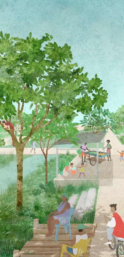
Water made Cartagena and now threatens it. Communities, institutions and professionals have been demanding safer living conditions and environmental justice for years, and that momentum is what the project runs on. Within a Dutch-Colombian consortium, Felixx led the spatial strategy and design process that turns the demand into a citywide water strategy and six projects ready for investment.
Key info
- Year
- 2023 - Ongoing
- Type
- Masterplan, Public Space, Research, Vision
- Size
- 8200 ha
- Location
- Cartagena, Colombia
- Client
- RVO
A city shaped by water, under pressure from it
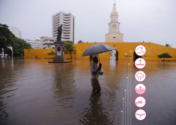
Cartagena's beaches, canals, lagoons and wetlands define its identity, carry its economy and hold its ecology. Water gives work, brings tourism and ties neighbourhoods to the city's heritage. The same closeness exposes the city. Extreme rainfall, high tides, storm surges and sea-level rise are all intensifying. In low-lying neighbourhoods with limited drainage and informal housing the impact is acute: flooded streets, displaced residents, degraded ecosystems and communities with little capacity to absorb the next shock. Social inequality and climate vulnerability are one problem here.
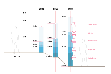
The problem is structural. The canal system around the Ciénaga de la Virgen drains large parts of the city, and decades of encroachment, pollution and underinvestment have cut its capacity. Drainage fails not because of isolated blockages but because the wider hydrological system has lost its ability to absorb, move and release water. Clearing one stretch shifts the flood to the next. The question the project set itself was what a productive relationship between Cartagena and its water could look like, and how to build it from the neighbourhoods where the water already stands.
Roots of Cartagena: seven ways water shapes the city
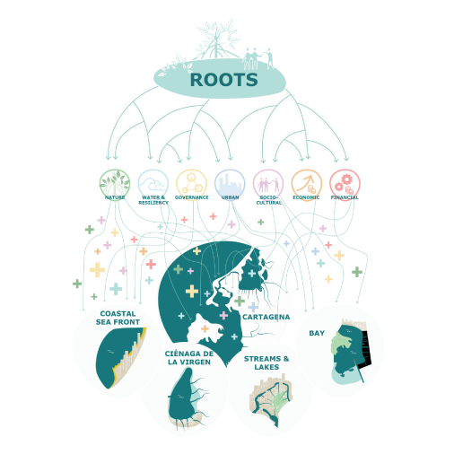
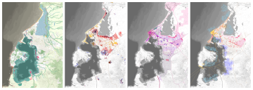
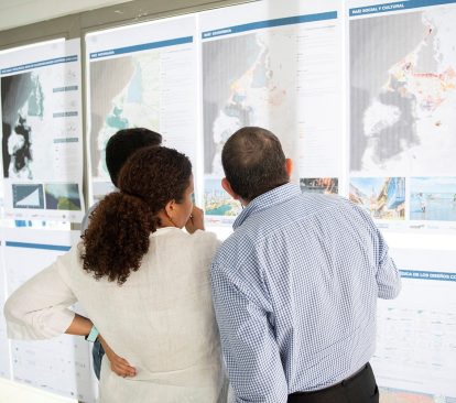
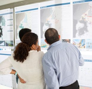
The core of the project is a reading of Cartagena along seven roots, each drawn as a map of the whole city. The Natural City. Water and Resilience. Water and Governance. Water and Urban Challenges. Water as a Sociocultural Determinant. Water as an Economic Driver. Water as a Financial Resource. Each map shows one way water shapes the city: where the ecosystems are and how they are faring, where floods hit and how often, who decides about water, where housing and infrastructure are under strain, what water means to the people who live beside it, what it earns and what it can finance.
Laid over one another, the seven maps describe a single system, and they tie the water system to the development of the city as a whole. Where the water stands longest, tenure and income are weakest. Where a lagoon edge recovers, jobs, public space and land values recover with it. That tie is what the rest of the project builds on.
A citywide water strategy
From the seven roots Felixx and the consortium drew one water strategy, written to support the development the roots point to. It works at the scale of the water system itself: the hydrodynamics, topography and ecosystems that run beyond the city limits. It defines its areas by what they share in nature, society and economy, with flood risk as one characteristic among several. Every water measure doubles as an urban improvement and creates investment opportunities for the communities it serves. Long-term masterplanning is tied to actions the city can take this year.
On the ground that means drainage made visible. Canal edges rebuilt as ecological and social infrastructure. Mangroves restored at the estuaries, where they hold sediment and break storm energy. Water squares and green buffers that take peak flows and remain part of neighbourhood life the rest of the year.
From strategy to six water landscapes
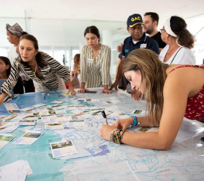
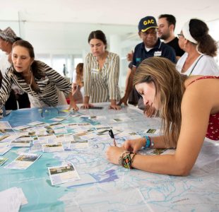
The strategy was turned into projects with the city. In co-design workshops in Cartagena, in July and September 2023 and after, residents, community organisations, public and private institutions and the consortium worked through analyses and proposals together. In one session the proposals were laid out as a market and participants voted for the measures they wanted. Technical and financial workshops ran alongside. Local knowledge entered as design input: what was spatially possible, what communities could maintain themselves and what would last.
The result is six strategic, integrated water landscapes. Each takes a part of Cartagena's water system, with the task it carries, and turns it into a project. Together they run from the open sea to the bay. Two of them protect the coast against the sea. Four work basin by basin on stormwater and drainage, and are designed to be repeated in the next basin once they have proved themselves.

The beach
The Marbella–Crespo coast, from the walls of the historic centre to La Bocana. The task is coastal pressure: flooding from the sea, erosion of the beach and a seafront with no good place to walk or cycle. The project makes the coast a park-promenade. The beach road becomes a boulevard with new development behind it, and the promenade runs on into the city. The first step is an elevated cycle route and drainage collectors, within eighteen months. Then the waterfront park and a sand motor that feeds the beach from the sea.

The mangrove coast
La Boquilla, the fishing community on the narrow strip between the Caribbean and the Ciénaga de la Virgen. The task is to keep the bond between the community and the mangrove intact while both come under pressure: floods from lagoon and sea, eroding banks, roads that go under. The project restores the hydrological connection between sea and lagoon at La Bocana and Punta Canalete, protects and replants the mangrove, renaturalises the beach, adds sustainable drainage and opens training centres run by the community. Later come seagrass and coastal ecosystems, urban tidal canals and raised access roads.

The lagoon
The canal zone of San Martín, Líbano and Salim Bechara, whose canals drain into the Ciénaga. The task is the canals themselves and the water they carry: stormwater and pollution running to the lagoon, and the lagoon flooding back into the streets. The project keeps the canals working as water, social and ecological space at once. Canals are cleaned and renaturalised, streets rebuilt as climate streets with drainage, and water plazas, water playgrounds and water towers become the neighbourhood's meeting points. In the long term a freshwater reservoir inside the Ciénaga regulates sea-level rise while keeping the lagoon's balance.

The streams
The arroyos Calicanto Nuevo, San José, La Princesa, Isla de León and El Limón, the Calicanto canal and its tributaries. The task is runoff: rain that falls on the high, partly rural parts of the basin and discharges into dense, low-lying neighbourhoods with no room for it. The project holds the water up high. Temporary storage and infiltration in the elevated areas, helped by limestone soils that drain well, sponge principles in El Triángulo, and the streams that feed the Ciénaga kept open and maintained. Canals cleaned, climate streets, reforestation, bioretention and floodable wetlands first, with training centres alongside. Later sponge neighbourhoods and parks, NbS on buildings, urban farming and a local treatment plant.

The rivers
The Caños and Lakes: two sub-basins in San Pedro, Petares and Daniel Lemaitre, on the steep slopes of Cerro de la Popa, running down to the Juan Angola channel. The task is water that races off the hill and erodes the channel banks below. The project starts high: reforestation and bioretention on the slopes, streets redesigned to slow the water on its way down, protected banks and mangrove along the channel. Along the canals a floodable Eco-Park is the pilot and the long-term axis: a tidal ecosystem where public functions and new development adapt to a floating environment. Later come the tidal park, flood gates and drainage pumps.

The bay
The basins of the Puerta de Hierro, Arroz Barato and Policarpa streams, running through the port and industrial zone into the Bahía de Cartagena. The task is connection: catching runoff upstream, bringing the streams through the harbour as one drainage network and protecting what stands downstream. The project restores and connects the natural drainage network, reforests wasteland, protects ecologically valuable banks and islands and gives port and industry local protection. Floodable areas in the neighbourhoods serve recreation. The remaining ecological space beside the port becomes a natural filter: mangrove that cleans the outflow, holds sediment, breeds commercial fish species and rises with the sea.
From strategy to six water landscapes
The strategy was turned into projects with the city. In co-design workshops in Cartagena, in July and September 2023 and after, residents, community organisations, public and private institutions and the consortium worked through analyses and proposals together. In one session the proposals were laid out as a market and participants voted for the measures they wanted. Technical and financial workshops ran alongside. Local knowledge entered as design input: what was spatially possible, what communities could maintain themselves and what would last.
The result is six strategic, integrated water landscapes. Each takes a part of Cartagena's water system, with the task it carries, and turns it into a project. Together they run from the open sea to the bay. Two of them protect the coast against the sea. Four work basin by basin on stormwater and drainage, and are designed to be repeated in the next basin once they have proved themselves.

The beach
The Marbella–Crespo coast, from the walls of the historic centre to La Bocana. The task is coastal pressure: flooding from the sea, erosion of the beach and a seafront with no good place to walk or cycle. The project makes the coast a park-promenade. The beach road becomes a boulevard with new development behind it, and the promenade runs on into the city. The first step is an elevated cycle route and drainage collectors, within eighteen months. Then the waterfront park and a sand motor that feeds the beach from the sea.

The mangrove coast
La Boquilla, the fishing community on the narrow strip between the Caribbean and the Ciénaga de la Virgen. The task is to keep the bond between the community and the mangrove intact while both come under pressure: floods from lagoon and sea, eroding banks, roads that go under. The project restores the hydrological connection between sea and lagoon at La Bocana and Punta Canalete, protects and replants the mangrove, renaturalises the beach, adds sustainable drainage and opens training centres run by the community. Later come seagrass and coastal ecosystems, urban tidal canals and raised access roads.

The lagoon
The canal zone of San Martín, Líbano and Salim Bechara, whose canals drain into the Ciénaga. The task is the canals themselves and the water they carry: stormwater and pollution running to the lagoon, and the lagoon flooding back into the streets. The project keeps the canals working as water, social and ecological space at once. Canals are cleaned and renaturalised, streets rebuilt as climate streets with drainage, and water plazas, water playgrounds and water towers become the neighbourhood's meeting points. In the long term a freshwater reservoir inside the Ciénaga regulates sea-level rise while keeping the lagoon's balance.

The streams
The arroyos Calicanto Nuevo, San José, La Princesa, Isla de León and El Limón, the Calicanto canal and its tributaries. The task is runoff: rain that falls on the high, partly rural parts of the basin and discharges into dense, low-lying neighbourhoods with no room for it. The project holds the water up high. Temporary storage and infiltration in the elevated areas, helped by limestone soils that drain well, sponge principles in El Triángulo, and the streams that feed the Ciénaga kept open and maintained. Canals cleaned, climate streets, reforestation, bioretention and floodable wetlands first, with training centres alongside. Later sponge neighbourhoods and parks, NbS on buildings, urban farming and a local treatment plant.

The rivers
The Caños and Lakes: two sub-basins in San Pedro, Petares and Daniel Lemaitre, on the steep slopes of Cerro de la Popa, running down to the Juan Angola channel. The task is water that races off the hill and erodes the channel banks below. The project starts high: reforestation and bioretention on the slopes, streets redesigned to slow the water on its way down, protected banks and mangrove along the channel. Along the canals a floodable Eco-Park is the pilot and the long-term axis: a tidal ecosystem where public functions and new development adapt to a floating environment. Later come the tidal park, flood gates and drainage pumps.

The bay
The basins of the Puerta de Hierro, Arroz Barato and Policarpa streams, running through the port and industrial zone into the Bahía de Cartagena. The task is connection: catching runoff upstream, bringing the streams through the harbour as one drainage network and protecting what stands downstream. The project restores and connects the natural drainage network, reforests wasteland, protects ecologically valuable banks and islands and gives port and industry local protection. Floodable areas in the neighbourhoods serve recreation. The remaining ecological space beside the port becomes a natural filter: mangrove that cleans the outflow, holds sediment, breeds commercial fish species and rises with the sea.
Each project grows in steps
Every project is drawn as a sequence, in section, from the first intervention to the full transformation. Each has a set of short-term measures that can be carried out in eighteen months to three years and a set of medium- and long-term measures that build on them. The first steps use what is available now: collectors and canals cleared and renaturalised, climate streets, reforestation on the slopes, a floodable park as pilot, training centres. They already reduce flooding and give the neighbourhood usable space. Later steps add the larger works as land, funding and governance come into line: the waterfront park and sand motor, the tidal park and flood gates, the urban tidal canals, the freshwater reservoir. Each step performs on its own and prepares the next, so a project keeps going when a funding cycle ends.
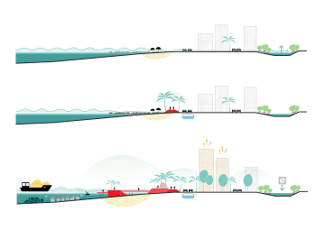
That phasing is what makes the projects investable. A municipality, a bank or a development fund can finance a first step, see it work and commit to the next. The six first steps together were estimated at around 460 million US dollars, the full programmes at around 1.4 billion. The strongest projects were developed technically and financially to pre-feasibility level, covering public space adaptation, water infrastructure and mangrove restoration, with detailed designs and implementation roadmaps to follow. Those studies define what to build, what it costs, who maintains it and how it connects to the city's governance.
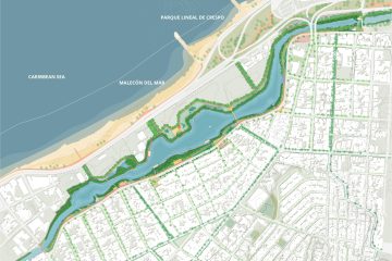
The projects also build local capacity. Training centres let residents gain expertise in water management, household adaptation and recycling. Squares, water towers and playgrounds double as flood infrastructure and shared neighbourhood assets. Protection and daily life occupy the same space.
Working together
Water as Leverage Cartagena is a Dutch-Colombian partnership facilitated by the Government of the Netherlands through RVO, in collaboration with the Alcaldía de Cartagena de Indias and Colombian national authorities, and financed through the Partners for Water 2022–2027 and PSD Toolkit programmes. Within Team Roots, Witteveen+Bos led the consortium and the water engineering, Felixx the spatial strategy and design process, Aqua & Terra the local engineering, the Universidad de Cartagena the research and local knowledge base, and CSC Strategy & Finance the financial strategy. Five knowledge streams, one set of projects that communities, engineers and financiers can all read.
Want to learn more?

Eduardo Marín Salinas
Associate partner in Spain, landscape architect, researcher- Location
- Madrid
- expertise
- Research by design
- Strategic planning
More info
- team
- Felixx
- Witteveen+Bos
- Aqua & Terra
- Universidad de Cartagena
- CSC Strategy & Finance
- photography/visuals
- Felixx
- La Cifra Impar
- awards
- 2026 Malaysia Landscape Architecture Awards [Winner]
- publications
- Water as Leverage
- Architectenweb
- World Landscape Architects


