Triple Dyke coastal strategy, Shenzhen
Living typhoon protection for daily life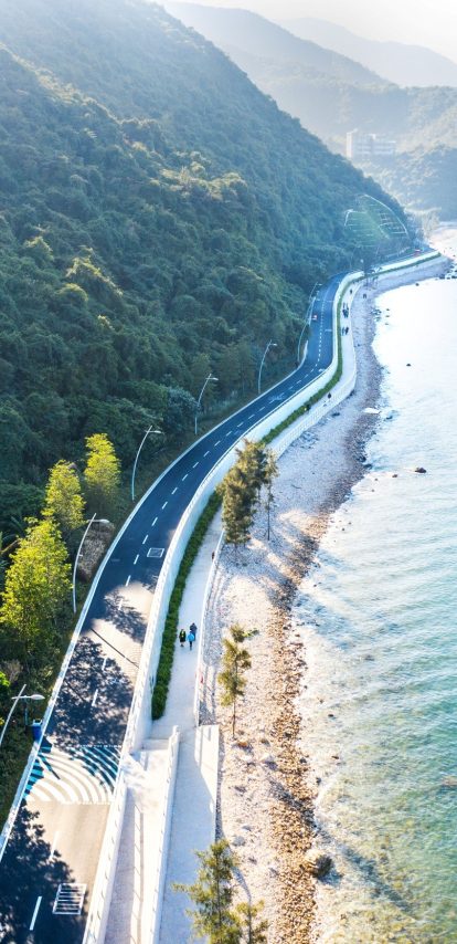
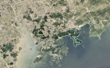
Typhoon Mangkhut struck Shenzhen's east coast in 2018 and destroyed it. Along the Dapeng peninsula — 130 kilometres of shore between the mountains and the South China Sea — beaches, roads and village fronts were torn up. Shenzhen commissioned Felixx and KCAP to raise the coast to a 200-year safety standard. The answer became the Triple Dyke: a strategy that spreads the work of protection across three zones, and keeps the coast open while doing it.
Key info
- Year
- 2019 - 2024
- Type
- Infrastructure, Masterplan, Public Space
- Size
- 1500 ha
- Location
- Shenzhen, China
- Client
- Water Resources Bureau of Shenzhen Municipality
- Status
- Realised
Safety as a landscape
A new sea wall was already going up when the work began. It held back the water. It also cut the villages from their beaches, the mountains from the sea, and the coast from the people who used it.
That mattered because four things share this shore. Typhoon exposure and storm surge. An ecological gradient running unbroken from mountain to sea. The weekend crowds of one of Asia's largest metropolitan regions. And fishing villages working through a socio-economic transition. The wall served the first and worked against the other three.
That reframed the brief. Safety on this coast is a landscape that holds all its functions together — shelter, habitat, recreation, fishing — in a new and safe form, across three districts, two river basins and nine coastal tourism zones. The 200-year standard is what that landscape has to meet.
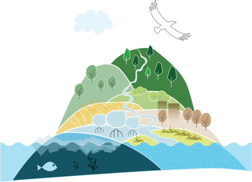
The Triple Dyke
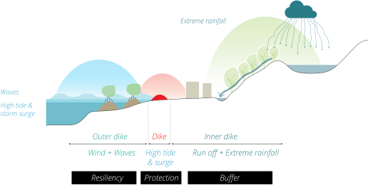
The Triple Dyke widens the defence from a line into a zone, and divides that zone into three.
The outer zone meets the sea first. It strengthens the coastal landscapes already there — mangroves, beaches, rocky shore, restored coral reef — so wave energy drops, erosion slows, sediment settles and biodiversity builds. Where exposure is highest, wave-gardens of robust beach vegetation and rock do that work.
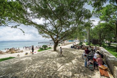
The middle zone is the primary seawall: an elevated embankment that stops the surge and the water the waves push ahead of them. It is built as public landscape — a hilly park, an elevated waterfront with promenades, a tidal park, in places a public building. Walls of shifting height make plazas and sheltered terraces. It is dimensioned for storm surge, wave action and sea level rise, and in extreme events it lets water pass through to the zone behind.
The inner zone catches what arrives from the other direction: rain off the mountains and the villages, rainfall on the coast, water overtopping the seawall. Rain-parks, rain gardens, wet forests, wetlands and green streets store, filter and delay it, on the sponge city principle.
Together the three zones carry the load the wall was asked to carry alone. Each is loaded with Nature-based Solutions, so water safety and the ecological, recreational and social life of the waterfront share one landscape.
One lens for 130 kilometres
The zones are also how the whole coast was read. Every strategy already at work along it — for water safety, for ecology, for tourism, for the villages — was looked at through the zones and merged into one spatial framework. That framework became the design code: each zone loaded with ecological and programmatic function, and those functions translated into the landscape of each stretch.
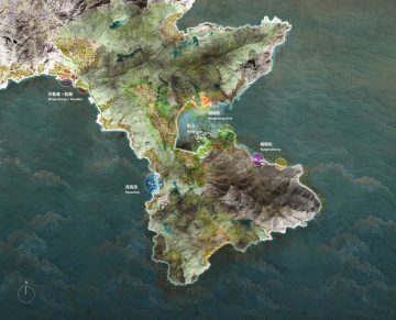
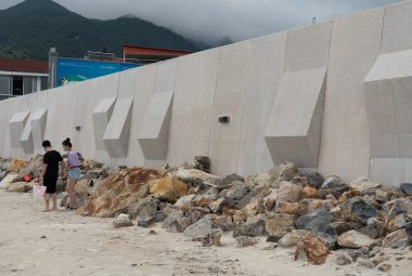
The code produces variety. Studies with Deltares showed how mountains, streams, beaches, villages and rocky headlands each meet the sea, and how each behaves in a storm. In exposed villages the edge is stony and robust. In calm bays mangroves shape it. At fishing harbours it stays open, so the boats can still work. Materials follow the same logic: robust stone and concrete face the sea, sand-coloured to match the beach; smaller-scale materials, planting and seating make the landscape inland, with local soil and stone recycled on site. What comes of it is a spectrum — engineered and urban at one end, hybrid in the middle, largely natural at the other — along the whole peninsula.
Safety does not have to mean separation. A coastline can protect people while staying open, ecological, and alive.

Triple dike section: Guanhu

Triple dike section: Moonbay

Triple dike section: Dongshan

Triple dike section: Yangmeiken town

Triple dike section: Mangrove

Triple dike section: Guanhu

Triple dike section: Moonbay

Triple dike section: Dongshan

Triple dike section: Yangmeiken town

Triple dike section: Mangrove
Natural design logic
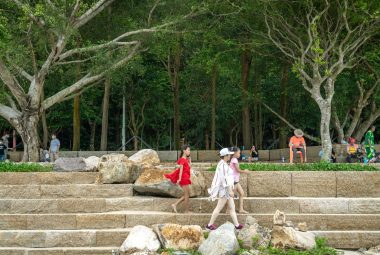
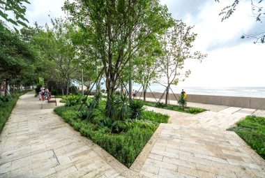
The design logic comes from the landscape. Each stretch is shaped to fit its own ground, so the design language changes along the coast. From sea to mountain, the materialisation follows the three zones. The outer zone is robust. Big blocks, strong materials, built to take the waves. The middle zone is linear. It runs with the coastline and guides you along it. The inner zone is refined and tactile — smaller elements, finer finishes, planting within reach. It feels sheltered and safe, and it invites you to stay. Together they turn the waterfront into an interface between mountains and sea.
Tested first at Yangmeikeng
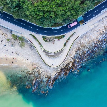
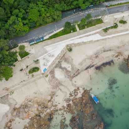
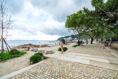
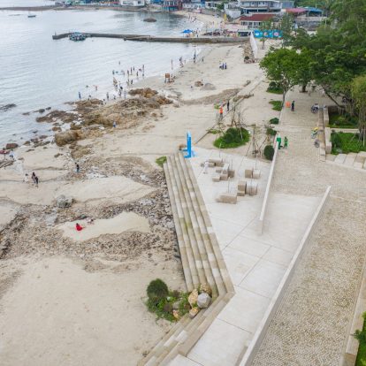
Before committing 130 kilometres to a strategy, the team built 500 metres of it. The Yangmeikeng Sea Boulevard opened in May 2020 as a full-scale test. Materials, construction techniques, drainage, public space details and finishes were all tried under real conditions with the local engineers, contractors and the client, and judged on durability, maintenance, how the water infrastructure integrated, and how the seawall met the local character of the waterfront.
The results were measurable. The boulevard drew around 30% more visitors, and local businesses reported roughly 20% more profit. That is the return on a different kind of investment: working with natural systems cuts the hard infrastructure the coast needs, and the budget that concrete would have taken goes into landscape, public space and ecological restoration. Protection becomes an asset. The lessons from the pilot became a repeatable framework, so the rest of the coast could be built with less uncertainty.
One code, many coasts
The code gives every stretch its own answer, and the typologies run into the dozens along the peninsula. Four examples show the range.

Yangmeikeng — mountain, village and sea
Squeezed between a geopark and a marine reserve, Yangmeikeng is among the most constrained stretches on the coast, and the old seawall had cut the village off from the water. A stepped seawall, a public promenade and rain gardens put that connection back. Natural beaches and rocky shore are kept, and the three zones are calibrated to the bay's mid-energy waves and its sediment.

Yangmeikeng Road — infrastructure as landscape
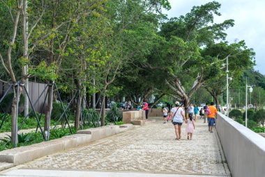
Along three kilometres, the condition is a road. Mobility, flood protection, drainage and public space are folded into one coastal profile. A stepped section carries traffic and pedestrians, puts the drainage in view, and opens out into rest areas, viewpoints and ecological edges. Fishermen, commuters and visitors use the same space.

Guanhu — a high-energy coast
Where waves are strongest and development pressure highest, the response gets heavier. Terraced embankments break up wave energy, reinforced beach systems hold the sand, and a linear park runs promenade and rain gardens behind a granite-edged stepped profile. The engineering is substantial, and the promenade still brings people to the water on the roughest days

Dongshan — restraint
Dongshan is largely natural, and the strategy there is to build little. No continuous coastal road is added. Built-up areas get targeted protection and the rest is left to recover. Mangroves are restored at the estuaries, a green dike park threads sea, wetland and mountain forest together, and the creeks work as flood buffers. The result reads as a green necklace along the shore.
Moonbay, Pengcheng, Shayuchong and the other stretches each sit somewhere else on the same spectrum, placed by their own wave energy, ecology and use
One code, many coasts
The code gives every stretch its own answer, and the typologies run into the dozens along the peninsula. Four examples show the range.

Yangmeikeng — mountain, village and sea
Squeezed between a geopark and a marine reserve, Yangmeikeng is among the most constrained stretches on the coast, and the old seawall had cut the village off from the water. A stepped seawall, a public promenade and rain gardens put that connection back. Natural beaches and rocky shore are kept, and the three zones are calibrated to the bay's mid-energy waves and its sediment.

Yangmeikeng Road — infrastructure as landscape
Along three kilometres, the condition is a road. Mobility, flood protection, drainage and public space are folded into one coastal profile. A stepped section carries traffic and pedestrians, puts the drainage in view, and opens out into rest areas, viewpoints and ecological edges. Fishermen, commuters and visitors use the same space.

Guanhu — a high-energy coast
Where waves are strongest and development pressure highest, the response gets heavier. Terraced embankments break up wave energy, reinforced beach systems hold the sand, and a linear park runs promenade and rain gardens behind a granite-edged stepped profile. The engineering is substantial, and the promenade still brings people to the water on the roughest days

Dongshan — restraint
Dongshan is largely natural, and the strategy there is to build little. No continuous coastal road is added. Built-up areas get targeted protection and the rest is left to recover. Mangroves are restored at the estuaries, a green dike park threads sea, wetland and mountain forest together, and the creeks work as flood buffers. The result reads as a green necklace along the shore.
Moonbay, Pengcheng, Shayuchong and the other stretches each sit somewhere else on the same spectrum, placed by their own wave energy, ecology and use
A coast that grows safer
The Triple Dyke is designed to grow. Each completed stretch protects immediately and opens that piece of coast to daily use. The 18 kilometres of embankment in the development focus stood by 2021; the access road and the Guanhu and Pengcheng zones followed in 2023.
Time works in its favour. Mangroves establish, rain gardens mature, sediment stabilises, and the coast grows more resilient as it ages. When conditions change, the system is upgraded stretch by stretch.
Working together
Four knowledge streams built on one another. Deltares supplied the hydrological foundation — wave dynamics, flood modelling, nature-based solutions data — which set what the coast could withstand and where. Hope Landscape & Architecture, the China Water Transport Planning & Design Institute and the local contractors brought the site knowledge that kept every decision buildable. KCAP and Felixx turned that combined understanding into the Triple Dyke strategy and the design code for the whole coast. China Resources Group managed design and construction, for the Water Resources Bureau of Shenzhen Municipality.


More info
- team
- Felixx
- KCAP
- Deltares
- Hope Landscape & Architecture
- China Water Transport Planning & Design Institute
- photography/visuals
- DUO Architectural Photography Hongduo Zhuo
- awards
- 2021 Rethinking The Future TF Awards [3rd place]
- 2021 A+ Awards [winner]
- 2020 WLA Awards [shortlist]
- 2020 Eurasia prize [winner]
- 2019 Competition winner
- publications
- Archdaily
- Archello
- Archiscene
- Architectenweb
- Blauwe Kamer E-zine
- Bright
- De Architect
- Dredging Today
- Dutch Water Sector
- e-architect
- gooood.cn
- Trellis
- moool.com
- Nexus Media News
- Outdoor Design Source
- QQ.com
- Revitalization
- Shekou Daily
- Straatbeeld
- Technisch Weekblad
- Tenderstream
- The Guardian
- Urbanica
- Worldarchitecture
- World Landscape Architecture

